Troy? In England?
Dear reader,
If you've turned to the historical note in a novel first, with the aim of better understanding what you're reading, please be clear that there are massive spoilers herein - and not just because I'm going to tell you how it ends. And yes, that is a joke of sorts when considering a three thousand year old story that 'everyone' knows, but then not everyone has read the Iliad and I'm willing to bet that even fewer of us have ever taken the time to delve into what little remains of the Cypria, the Aethiopis, the Little Iliad, the Ilou Persis or the Nostoi, the companion (and mostly lost) epics which are all pertinent to this trilogy as they tell the wider story beyond the Iliad's short time period within a ten year war. You are perhaps - given the careful suggestions at the front of the book to read the story first and consider this note/look at the maps thereafter - still either puzzled at some of the content or just happily unaware of the nature of the concept that underlies the whole thing. So allow me to explain, and all will hopefully be a little clearer - even if perhaps challengingly so.
Every historical fiction novel I have ever written has always contained a historical note - not that my work is unique in that, far from it. But never before has one of my books, or the two that are to follow Swords of Troy, if you are reading either Heroes of Troy or Fires of Troy, needed such an explanation of the 'history' contained herein quite so much. And in the following pages I plan to explain what it was that led me to wrote this somewhat different version of the Trojan War and, equally importantly, why what I've done here is not quite as implausible as it might initially seem. But first I must express my gratitude to the man who came up with this challenging - to put it mildly - alternative take on the Iliad and all of the other (now mostly lost) epics, named above, the initially verbal histories that detailed the story of this struggle between two such well-matched armies over a whole decade of fighting.
Where Troy Once Stood: The Wilkens Hypothesis
Iman Jacob Wilkens was born in 1936 in the Netherlands, and died in 2018 at the age of 82. And there is little more that I would have enjoyed than discussing his theories with him. Because whether you agree with his views or not, the effort that he put into his book 'Where Troy Once Stood' spanned over thirty years and built up a body of thought - and a variety of what he deemed to be strong evidence that stands today as an intriguing alternative to the established but in parts surprisingly flimsy accepted historical narrative. What I propose to do here is to provide you with the main tenets of his treatise, partly because his book is a rarity, being out of print, and partly because I want the reader to understand the reasons why I felt that this trilogy was worth writing despite the incredulity it will undoubtedly attract from those with professional status in the area of Ancient World studies.
To be clear about two important points, firstly, I am not any sort of ancient world historian (I can hear at least one of my literary peers laughing at the very idea even as I write the words). I do not have any professional basis for asserting that Troy was not situated in Turkey, and neither do I seek to make any pretence to that expertise. I am a fiction writer who read 'Where Troy Once Stood' and thought that there could be a really interesting and enjoyable piece of alternative 'historical' fiction to be written. I put 'historical' in quotes, both because it's obviously impossible to read the Iliad as straight history given its dependence on the members of the ancient world's pantheon of squabbling gods to drive the narrative, and due to the massive inconsistencies between the epics and the real world that Wilkens points out at length in his book. Is 'alternative mythology' perhaps a better fit? I'm quite sure that Wilkens would not have agreed. He believed that the events of the Iliad - and all of the other lost epics - really happened. Just not in the Aegean.
And secondly, please do not mistake what follows here as in any way being my research. I do not seek to avoid any potential mockery from those offended, personally or professionally, by the views that I will reflect here, but neither will I take any credit for those views when they are based on another writer's life work. While I find some of Wilkens' statements of what he felt to the truth behind the Trojan War myth to perhaps be trying a little too hard, I feel that his core arguments are at the least a decent challenge to the somewhat flawed - as I hope to show, using his arguments - albeit widely accepted narrative of Troy having been an ancient city in Turkey that was attacked by the Greeks.
So let's allow Mr Wilkens to explain his theory to us in his own words - I will paraphrase, to avoid the laborious and pointless task of reproducing his entire book, which is worth tracking down for a proper read if you're ready to go all the way down the rabbit hole - exactly why it is that he believes that Troy was indeed a real place (but just not where you think). From here on I will [bracket] anything I wish to say alongside Wilkens' comments, so that you can be assured that what you're reading is a reasonably direct precis of those parts of his work bearing on the Iliad (it goes into the Odyssey as well) and trimmed to present the more accessible evidence. And while there is a lot of very well referenced research behind his claims I'm not going to provide these references, so if you wish to pursue them I suggest a purchase of the later edition of his book. So, let's look at some major questions...
Why was the Trojan War fought in the first place?
There are two schools of thought here. Homer's stated reason was the abduction of Helen of Sparta, the wife of Menelaus, brother to the great king Agamemnon. Wilkens view is that the Trojan War was a major conflict between the peoples of the Western European coastal lands and the British Isles for free access to a raw material found almost exclusively in Cornwall and which was as essential to Bronze Age life as crude oil is now. This was tin, essential to the production of bronze of which it is roughly ten percent. When the tin mines in Brittany were exhausted by 1200 BCE arsenic naturally found within copper was substituted for tin as a means of induration (hardening) copper, turning it into arsenical copper, resulting in much less durable metal and requiring laborious cold working as opposed to simple casting. This had been the technique used prior to the discovery that tin did the same thing, without the cold working and also without poisoning the smiths involved and produced a far superior result. Clearly without tin, and therefore with no source of bronze, the Continent would return to the primitive living conditions of before and iron, while it was the answer in the longer term as metallurgy improved, was no solution in the short term as it was only usable in its most primitive form and therefore no substitute.
The diplomatic mission to Troy by Odysseus and Menelaus might well have been the last gasp attempt at a peaceful trade based solution to Argos's need for tin as well as having to do with the matter of Helen, Menelaus's wife who had been 'abducted' by Paris, a Trojan prince. But if it was, it seems to have been doomed to failure simply because there was nothing that Troy needed from the coastal European kingdoms, being rich in gold, silver, copper, hides, wood, horses, cattle and ships. Which meant that Agamemnon, ruler of Argos, could either accept decline and eventual military defeat by Troy or launch an all-out war to take what his kingdom needed to survive by force. Thus it was that Agamemnon, the 'wide-ruling king' and 'leader of men' had no choice but to unleash the Trojan War.
How did Troy come to be considered a place in Turkey - and is this likely to be true?
Homer's Iliad describes a short portion of the Trojan War, in its final year of ten, which took place in the Bronze Age around 1200 BCE. The detailed nature of the descriptions suggest that the works were composed by one or more contemporaries of the conflict [history's first war reporters, perhaps] and passed on orally until they were written down in Greek centuries later around 750 BCE. We can imagine the epic, and the others in the sequence that told the backstory to and the end of the war, and the events that followed in the Odyssey, being performed by bards who had learned them by heart to rapt audiences around fires and in halls, their tale of swift footed Achilles the consequences of his anger, holding the listeners rapt attention. But while there is no doubt that the eventual written versions originated in Greece about four hundred years later, there are substantial reasons to believe that the oral versions of the epics [remember, the Iliad is only one part of the original story] originated somewhere else, and were carried to Greece where fortunate happenstance led to their being committed to the written record. This is not intended, of course, to denigrate the prestige of Greek classical culture as it developed after Homer.
The current accepted narrative is that the Trojan War as described in the Iliad was fought on the plain near the village of Hissarlik in north-western Turkey. This 'truth' remains unchallenged in mainstream historical thought as very little is known about the Greek so-called Dark Ages, a period from about 1200 to 750 BCE, which led to great uncertainty as to the site of Troy and even the Iliad's real degree of historicity.
In the late 19th century a German called Heinrich Schliemann excavated ancient ruins on the hill of Hissarlik, and promptly [and loudly] claimed to have discovered Homer's Troy. He called the site 'Troy' and 'Ilium' despite the lack of either those names or any trace of the war being found in the region. He was given the benefit of the doubt as the site was close to the ancient Hellespont, and to several islands named by Homer, such as Lesbos, Tenedos and Samothrace, but there is no hard evidence that Hissarlik was called Troy or Ilion prior to the 8th century BCE when the first Greeks settled there.
Having uncovered the remains of a series of superimposed towns [different ages of the same settlement stacked on top of each other over time] by the simple, swift but remarkably destructive dint of digging a massive trench straight through the hill, Schliemann boldly stated that the oldest but one layer was Homer's Troy, as it was here that he claimed to have found the 'Treasure of Priam' [a cache of gold and other artefacts that Schliemann somewhat brazenly assigned to the Trojan king Priam]. Later research dated that stratum to 2600 to 2200 BCE, at least a millennium before the events of the Iliad. Added to which inconvenient revision the circumstances of the find are very much open to question [Schliemann was something of a dubious character, and it would seem likely that he gathered the artefacts in question on the open market and faked their discovery in order to both aggrandise his reputation and make money - I recommend the biography ‘Schliemann of Troy: Treasure and Deceit’ by David A. Traill if you wish to know more about him and the audacity and indeed apparent mendacity of his dealings in the pursuit of fame and fortune, it's a balanced view but somewhat damning].
Later excavation led to the revised belief by later archaeologists that it was not 'Troy II' but rather Troy VIIa, [the first iteration of the seventh layer of the settlement] that was Homer's Troy, because this was destroyed by war around 1180 BCE. The problem with that is that the Mycenaean palace culture that was Troy's mortal enemy in the Iliad [Agamemnon being the king of Mycenae] had already been destroyed by that time, most probably by the still mysterious Sea Peoples [who seem to have overrun the Mediterranean around that time and at least partially engendered what ancient historians call 'The Late Bronze Age Collapse', only being successfully fought off by the Egyptian pharaoh Rameses III in c1175 BCE which victory resulted in a rare written record of their existence in the hieroglyphs of the time].
And that could have been the end of the search for the Trojan War in north-west Turkey, except the residual belief in it despite the facts [a 'need to believe', perhaps] is so strong that the outcome of that search has been declared as merely 'inconclusive' by such luminaries as Michal Wood, whereas in truth the likelihood is that Troy VIIa was also destroyed by the Sea Peoples. Certainly none of the forty odd descriptions of Troy in Homer fit Hissarlik or the region, and no significant remains of the Trojan War have been found, only a few bronze arrow heads and spear points.
The fact is that neither Hissarlik nor the adjacent plain fit with the Iliad, as Homer called it a 'big city' with 'wide streets', whereas Hissarlik is in reality a village about the size of a stadium. Even Schliemann admitted that it could have had no more than 5,000 inhabitants, and yet 50,000 warriors are supposed to have garrisoned the city, and a ten year siege of such a small settlement feels less than likely. The plain is also far too small to have been the site of a major war with 100,000 men on the Achaean ['Greek'] side according to the Iliad's 'Catalogue of Ships' [a list of the tribes that went to war, their point of origin and their strength], a size of army requiring what Homer called the 'wide camp of the Achaeans' for which there can have been no room on the plain as it was at the time [see map 1, the accepted view of the battlefield, and note that the plain as it now is has silted up with riverine sediment and was much less substantial three thousand years or so ago]. Where are the eight rivers which flooded the Achaean camp after the war, and where are the twenty-three cities destroyed by Achilles in the course of that ten year war?
It seems unlikely that the bay of Hissarlik would have been large enough to contain 1186 ships [again, see the Catalogue of Ships] and the strong currents in the area would have made a landing very difficult. And wherever the fleet landed and was beached, the army would have had the handicap of having to cross the river Scamander each time the Achaeans advanced to combat, but no mention of this can be found in the Iliad. Furthermore, the Scamander and the Simois rivers joined, as described in the Iliad, but the corresponding rivers in Turkey, the Kara Menderes and the Dumrek Su, do not do so [although there is a place, however, where two similarly named rivers do join on a plain, as Homer described, it's not in the Aegean].
There are also problems with the geo-political topography of the area. Hissarlik is not situated to control the trade route between Europe and Asia and therefore be a target for conquest - whereas the Bosphorus [a name which literally means 'cow crossing'] certainly is, leading to the great world city of Byzantium springing up on the straits in the fifth century BCE, so there was no practical reason to take the 'city' especially as the Greeks had little or no trade with the Black Sea at the time in any case. And neither does Queen Helen's abduction justify such a huge [and ruinously expensive] expedition that ended up costing more than one of the Achaean kings his throne and his life.
Certainly there is less than total unanimity among the academic community that Hissarlik is actually Troy. If a major war had been fought on this ground then there would be significant traces, including much bronze weaponry, but none have been found. No less of a luminary of the academic community than Sir Moses Finlay, [Cambridge professor of ancient history and master of Darwin College in the 70s and early 80s] stated that 'we are confronted with this paradox, that the more we know the worse off we are' with the conclusion that 'Homer's Trojan War must be evicted from the history of the Greek Bronze Age' [and this is a hard opinion to understate, as Finlay was the mentor to the university's next generation of ancient history academics who have recently retired and who still seem to believe that Wilkens is utterly mistaken in his beliefs, largely for lack of evidence it seems despite an apparent lack of any evidence to refute his belief that Hissarlik cannot be Troy]. Even the four experts who put together a major exhibition on Troy in 2019 were clear that 'archaeology gives no evidence for the Homeric poems'.
Interestingly, Troy VIIa was soon rebuilt as Troy VIIb1, inhabited from 1180 to 1100 BCE, but a shadow of its former self and culturally very different, with hand-formed 'barbarian ware' rather than wheel turned pottery, the potter's wheel having previously been in use since Troy II. They left, it seems [and Wilkens hypothesises that they were actual refugees from a Trojan War fought elsewhere], abandoning the settlement to more or less stand empty for centuries until the Aeolian Greeks took it over in the eighth century BCE, one of whom was 'Homer' [believed not to have been a single person]. After a long period of oral transmission of the story it was committed to writing, along with several other components of the same story [the other epics referred to above]. And it is from this period that the mystery surrounding the Trojan War dates, a war originally fought between two groups who then became immigrants who latterly settled on either side of the Aegean, but who fought that war a long distance from Greece and Turkey. It turns out that the story of the greatest war of prehistory, the Iliad, migrated with the Sea Peoples from Western Europe to the Mediterranean!
[Timeout: let's just mull on that for a moment. The Trojan War, says Wilkens, was fought in Western Europe, not in Turkey. And then whatever it was that caused the Sea Peoples to leave their coastal kingdoms in Spain, France, the Netherlands and Scandinavia,, a devastating migration that overran and destroyed the Bronze Age culture of the Mediterranean with the apparent sole exception of Pharaonic Egypt, resulted in them bringing their oral record of the war with them to the Greece they conquered. And then, with the rediscovery of writing in the 8th century BCE, 'Homer' wrote it down as the 'Iliad', and much besides, transplanting the myth from its point of origin to the Aegean. It's quite a claim. So let's take a better look at the evidence he presents.]
The Evidence for Troy in North Western Europe
Anyone reading the Iliad for the first time without preconceptions would not locate the theatre of war in the eastern Mediterranean were it not for a number of familiar place names [we'll be looking at these in more detail later]. Homer mentions a dark and misty sea subject to strong tides [the tidal range in the Mediterranean being a matter of a few inches, barely noticeable], a climate characterised by rain, fog and snow, and the trees are mostly those of a temperate oceanic zone, not the dry region of Asia Minor. Moreover, the tall, blond, clear-eyed and long-haired warriors, roaming the sea in 'symmetrical' ships, evoke strong association with Dark Ages Norsemen. Several commanders [including Diomedes, one of this book's protagonists] had the title 'sacker of cities'. As the ancient Greeks could hardly believe that these were their ancestors they relegated them to an imaginary 'Heroic Age'.
Even the earliest Greek historians lived too long after the conflict to verify its authenticity. The historian Thucydides, in the sixth century BCE, concluded that before his time 'nothing in Greece reached great proportions, the wars no more than anything else'. Navigation and trade barely existed, and so contact between the various tribes was tenuous at best. Widespread piracy caused travel by land, not sea, to be the norm. Thucydides could not understand how his country could have started a great war against Troy, and related his belief that Mycenae, Agamemnon's 'opulent' city with 'broad streets' according to Homer, had always had no more than 600 inhabitants [meaning that in Thucydides' reality a Greek Trojan War would have pitted one small village - and its allies, for balance - against another slightly larger settlement - hardly the stuff of a thousand ships, even had such a naval force actually been possible at the time].
Thucydides also mentions the presence in parts of Greece of 'barbarians' [the Greek tern for foreigners], in particular the 'Taulentians of the Illyrian race' The Illyrians, believed to have originated in the Celtic world by some academics, became so influential that Greece and the southern Balkans were lumped together as the prefecture of Illyricum by the Romans. Another group of incomers who took root in Greece in the Bronze Age were the Pelasgians, who founded Athens, gave names to many places in Greece and, after several generations, adopted the Greek language. These Pelasgians - cognate with the Greek noun pelagos, sea, were in reality the Sea Peoples.
These migrations into Greece during the Bronze Age would explain Plato's serious doubts as to the Greek origins of the Iliad and the Odessey. And as European academic thought came to life suspicions similarly grew that Homer's epics originated not in Greece, but in western Europe. As early as 1790 it was hypothesised that the Cimmerians (as mentioned by Homer) were of northern European origin because they are mentioned in connection with the wild or 'singing' [Whooper] swan, found in Siberia and Scandinavia, and in winter Denmark, the Low Countries and the British Isles - and seldom in Greece. The Mediterranean countries are much more familiar with the mute swan. In the early 1800s it was hypothesised that the Odyssey described parts of the British Isles, and that the historical background to the Iliad should be sought in Western Europe, not Greece. Other nineteenth century scholars stated that Odysseus sailed in the North Atlantic and that Troy, his starting point, was situated near the Wash in England. All of which was of course swept away by Schliemann's discovery of 'Troy' as Hissarlik late in the 19th century and which spawned a century and more of academic compliance with that supposed truth.
It is not possible to follow the events of the Iliad (or the Odyssey) on maps of Greece, Turkey and the Aegean Sea. The description of place and the distances between them, as well as the travel distances, seldom relate to the physical reality, akin to a jigsaw that has been jumbled, which explains the lack of agreement between scholars as to Homer's geography. But if we retrace these place names to Western Europe - where some 300 of them are still to be found [this is going to be an interesting subject later] - all the pieces fall into place and make the events described by Homer both logical and comprehensible. The Sea Peoples transferred place names to the Mediterranean, just as European emigrants did the same in the New World, a process aided by the sparse population of Greece at the time. It is perfectly possible to identify the location of Troy and some 300 other places, including the points of call in the Odyssey [and while for the sake of brevity the latter will not be dealt with here, Wilkens' conclusions as to these points of call are as mind blowing as his theories as to the Iliad].
This implies that an ancient Celtic culture existed in Europe long before the civilisation of Ancient Greece, on which it had a great influence, and throws a new light on the Dark Ages of Greek history from 1200 to 800 BCE. Let us look at some of the more detailed evidence for this [and I have omitted some of Wilkens' more arcane theories to present ideas that are generally more accessible to this audience, purely on the subjective basis that if I can't get a grip of them most readers might find them equally nebulous - read 'Where Troy Once Stood' if you really want to grapple with his full theory].
The combatants' names are our first indication of the location of the conflict. The attackers of Troy are called 'Achaeans', remote ancestors of the Greeks, which is why many translations use the term 'Greeks' and simply ignore the anachronism. The Achaeans were an Indo-European people who invaded Greece, not overland but from the sea, and they were indeed the infamous 'Sea Peoples' who seem to have been the progenitors of the Late Bronze Age Collapse. They originated [in Wilkens' opinion] from the coastal regions of Western Europe, and their name, 'Achaeans' is derived from an Indo-Germanic root akwa, meaning 'water' or 'stream', just as with the Latin aqua and the Gothic acha. Called Ahhijawa by the Hittites, and Aqaiwasa by the Egyptians, the form Achaiwia seems to the oldest name for Greece - 'land of the Sea Peoples'. Interestingly, given that the epics were written by Homer in Ionian Greek, the 'Ionians' are only mentioned once. Significantly, Thucydides is adamant that the Ionians - who were Athenians - and the other Greek tribes had no large fleets of the type described [1186 ships] until many generations after the Trojan War.
The ocean and its tides are also highly pertinent. The Iliad, and even more so the Odyssey, are epics of seafarers, in Homer's words 'friends of the oar'. And the sea, which he calls the ocean, is omnipresent in his works, but the colour blue is never used to describe it. The sea is instead grey, black, wine-dark, salty, misty, whitening, brilliant, turbulent, dangerous and immense, with waves as high as mountains and birds that 'do not even come back for a year', which hardly sounds like the Aegean. And the Greeks never used the term okeanos - ocean - to describe the Mediterranean, but only pontos, pelagos, hals and thalassa. For them the ocean was the 'river that surrounds the world' outside the Mediterranean basin, which they described as tidal, with ebbs and flows.
Strabo [an Ancient Greek geographer in the 1st century BCE] concluded that Homer [or whatever oral history he was transcribing] was not ignorant of the 'ebb and flow of Oceanus', and concluded that several key events described by the poet must have taken place in the Atlantic Ocean, which was well known at least by hearsay by that time. This phenomenon of tides is so important an argument that the epics could not have taken place in the Mediterranean as to make all other arguments virtually redundant, given the tidal difference of metres outside of the Mediterranean within which it is mere inches. Given that Homer describes seafarers using the tide to float their ships up hand dug channels to the high point of the beach, and the next tide to float them off again, it is highly unlikely that this action could have occurred in the Mediterranean.
Climate, too, is a powerful contra-indicator of a Mediterranean setting for the Iliad's action. Homer speaks of 'measureless rains' on the battlefield, such apparently ceaseless rainfall fitting far better to an Atlantic climate than that of the Aegean. There is also description of thick mist of the sort that London used to be famous for, in which 'a man can only see as far as he can cast a stone'. Troy is 'whipped by winds', with snow, hail and freezing temperatures - which to be fair is possible in an Aegean winter - but at no point does Homer refer to the likely obverse of such weather, the mild Mediterranean climate and long hot summers that one would expect.
In the area of vegetation there are more inconsistencies, especially with regard to trees. The beech is rarely found in Mediterranean countries, and black poplars prefer moist soils and are generally found near rivers, ponds and canals, with willows having a similar preference. The mention of deep forests is complimented by other indications that the poet was describing temperate zone vegetation except for one place, Odysseus's kingdom of Ithaca, where the essentially sub-tropical olive tree grows [Ithaca being in the vicinity of Cadiz in the Wilkens' version of this reality]. There are mentions of vineyards, but in the Bronze Age, when summers were even warmer than they are today, there were vineyards all over Northern Europe and indeed traces of cultivated vines have been found as far north as Sweden dating to around 1000 BCE. More than this, Homer mentions 'thick turf' and the Trojan plain being 'beautiful with its orchards and wheat fields' and 'it's lush meadows dotted with flowers' which is where the Achaeans make camp. Most of the regions described seem to be rich in deciduous trees, and none of these descriptors feel like an Asia Minor that may well have been significantly warmer than today.
Wilkens mentions several other factors that mitigate against Troy being in Turkey - horses, food, religion, art, philosophy - but the other major topic that's worth outlining here is the question of dykes. Homer often mentions dykes, which he calls 'the splendid works of young men'. These artificial land features - raised wall like mounds of earth stretching across countryside to prevent the ingress of flood water - are common in the lower lying areas of Europe but rare in Ancient Greece, which would mean that a Greek audience for the epic would probably have struggled to relate to the concept. His text, referring to 'close-fenced embankments' to 'stay its sudden coming [of a flood] when the rains of Zeus driveth it on' imply that the epic's original audience, hundreds of years before Homer's transcription, would have been familiar with the concept. We will come back to the concept of the dyke in warfare, as it will be important to the evidence of the location of the real Troy.
[Timeout: So, let us assume that Troy was not in Turkey, for all of the reasons mentioned above and more that you would have to buy Wilkens' book to explore, although these are the most cogent and easy for us to relate to in such a brief discussion. If not Turkey, or the Mediterranean for that matter, then where was it? For many reasons already laid out, we are looking for a location in a region bordering the Atlantic - although few academics have dared to scratch the epics' hallowed surface, and academic infamy has tended to attach to anyone doubting the received truth of Greece versus Turkey. Wilkins was certainly belittled and mocked by the academic community for the suggestion he made as to its location There are forty specific descriptions of Troy's environs in the Iliad, which seems as good a place to start in narrowing down the location as any other. For the sake of all of our sanity I don't plan to describe them all in a list, but rather to consider, as Wilkens did, in his book, some key considerations and wrapping them in as appropriate.]
It is clear that the Troad, Troy's hinterland, is near the ocean. Various comparisons in the epic [such as comparing the shouting of the Trojan warriors with the cries of the cranes that fly with onset of winter and incessant rain and make for the Ocean stream] would only have been understood by a Northern European audience at the time of its composition soon after the war's end. And this ocean has to be the Atlantic, for the Greeks never called the Mediterranean 'Oceanus'. If the Achaeans and Trojans lived on different sides of the ocean [hence the 1186 ships needed for the invasion of the Troad but which could not have crossed ocean spanning distances as a formed fleet with the available technology - sails and oars] then a logical candidate for the Troad is England. And the wide bay of the Wash is far better suited to receive a large fleet than the bay at Hissarlik.
In 1879 a Belgian lawyer called Theophile Cailleux wrote that Troy was situated in East Anglia, where he had discovered two huge war dykes between Cambridge and the Wash. He identified the river Cam with the Iliad's Scamander, and the Great Ouse with Homer's Simois. He was convinced that Homeric Troy was located on the Gog Magog hills outside of Cambridge. But he did not continue his research as he was unable to deal with one big problem: if Troy was in England, where did the 29 regiments of invading Achaeans come from? And where was Mycenae, Agamemnon's city?
Turning to Homer's 23 rivers [an improbable number given the small area accorded to the Trojan plain and the Troad at Hissarlik], nine on the Trojan plain and many others elsewhere in the Troad. Their names have been considered as the fruit of the poet's imagination, but they are in fact crucial to locating Troy. Homer describes how the flooding of eight rivers swept away the Achaean camp-wall after the war [the Rhesus, Heptaporus, Caresus, Rhodius, Granicus, Aesepus, Scamander and Simois], and the Iliad describes a ninth river [the Satniois] near the battlefield, with the Caystrius, the Axius and the Temese further away [Wilkens proposes current river names for all of these, but for reasons of space we'll focus on a few major examples]. Eye-openingly, when we consider these names and compare them to current river names in the area, there is a surprisingly close correlation after 3200 years of linguistic change. The Scamander, for example, could well be the Cam, the Simois could be the Great Ouse and the Satniois the Little Ouse [I personally find this combination intriguing]. The Cayster could be the Yare (near to Caister), the Axius the Exe, and the Temese perhaps the most obvious of all as the Thames.
Despite their 300 year age and transcription into the Ancient Greek the river names in the Iliad show great similarity to the actual rivers in England, both individually and as a group - although some of them have changed course, some have been canalised, a good example being the Caresus which might well now be the Car Dike, having been the Karesdic in the Middle Ages and indeed having previously been canalised by the Romans. The river evidence is compelling.
Another rich area of evidence for Troy in eastern England are the war dykes. Frequently raised as objects of speculation in the regional press, there are two enormous dykes north east of Cambridge, the Fleam Dyke and the Devil's Dyke. These have no obvious hydraulic function and can only have been intended to present a military barrier linking the Scamander/Cam in the west with the dense forests in the east, and run across a plain that had already been cleared of trees by 1500 BCE according to the archaeological research. These seem to have been barriers to defend against chariots, with ditches dug in front of them to foul horses' legs, although it has never been clear which war caused them to be built. Never mentioned by Roman historians and therefore probably of little use to the Romans, the discovery of a Roman coin under the Fleam dyke nevertheless 'dated' them to tribal warfare between Mercia and the East Angles in the sixth and seventh century AD. And while this seems to have been the case, elements of older earthworks seem to have been the base for this further development, confirmed by the discovery of Bronze Age potsherds. It also seems likely that Fen Ditton - the 'High Ditch' - is a continuation of the Fleam Dyke near the Cam.
These massive features - for what remains are twelve and six kilometres in length with an average height of five metres and a ditch four metres deep, and an overall width of dyke and ditch of thirty metres - implies a significant army at work to build the two defensive lines which run parallel at a distance of ten kilometres. This also implies that they might well have been contemporaneous. And the ditches in front of the dykes are south facing, presented to the inland side, which strongly implies that they were built by invaders from the sea and not by the defenders. As Homer gives us to understand that the Achaeans controlled the plain during the first years of the war, sadly not covered in the Iliad, and to the extent that Trojan sallies were rare, the invaders would have had the time to build the dykes at their leisure. Dykes are often not mentioned in translations to English [even the esteemed Emily Watson's beautiful recent translation] as they render riderless chariots being carried by their terrified horses 'over the wardykes' (ana ptolemoio gephuras, where the word ana means over, ptolemoio is war and gephuras are dykes without palisades) to translations such as 'along the dykes of battle', 'the space between the armies' or 'between the channels of the fighting', and this unintentional oversight is understandable given the lack of any such feature on the plain of Hissarlik - but this is critical evidence for Troy being located close by.
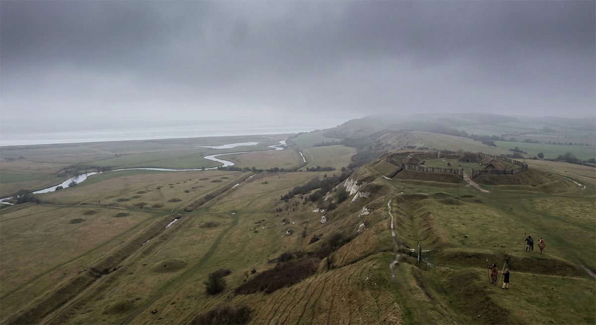
If this dyke evidence is valid then it isn't hard to find the hills on which the 'steep and windy city of Troy' with its 'wide streets' was situated, on the Gog Magog hills south of the Fleam Dyke and a few miles from Cambridge. This strange name is a reminder of the most terrible war of pre-history, mentioned by the prophet Ezekiel in a warning to the people of Isreal, an attack by an alliance of peoples wearing armour and accompanied by horses under the command of Gog, king of Magog, resulting in such carnage that the birds came to feed on the flesh of kings and heroes. And since many human bones and bronze weapons have been found in the vicinity of the Gag Magog hills, these might be silent witnesses to a great war that has passed from memory. In 1903 farmers reported the discovery of a great number of bones in the area to one Professor McKenny Hughes, who discovered, in addition to bronze objects and pottery, the remains of a possible massacre with many bodies of young and old of both sexes thrown into a ditch.
The hills form a plateau at a height of 80 metres above sea level, and, being eight square kilometres in area, more than enough ground in which to house a large city. Water was available from several springs, in particular Springfield near Cherry Hinton and Nine Wells at Great Shelford. So why has it never been seriously considered as a potential site of Troy? In the Roman era Hissarlik was a thriving town, and yet Ovid, sailing past on his way into exile, wrote 'now there are fields where Troy once stood' [Wilkens' italics, the book's title] - a nonsensical comment if Hissarlik were genuinely believed to be the site of the ancient fortress city. Whereas the Gog Magog hills were indeed covered with fields in his day, perhaps the result of the utter destruction of Troy at the war's end. Could it be that Ovid knew of the true location of Troy?
What archaeology has been carried out in the area has resulted in the discovery of defences at Copley Hill and Cherry Hinton, and the sites are known to have been occupied in the Bronze Age. In the middle of hills lies Wandlebury Ring, a fort with several concentric ditches and earthen walls kept in place by wooden palisades, within which many, often mutilated, skeletons were found as well as bronze and iron objects and pottery, including 'Knobbed Ware' dating to the Bronze Age. The acropolis, the 'high citadel' of Troy was called the Pergamum, cognate with 'berg' in the Germanic languages, 'height' or 'mountain'. The Pergamus in a Gog Magog based Troy must have been the highest part, and therefore would have been Wandlebury Ring at a mean height of 74 metres and 80 on the northern side, with a full view of the plain.
There is also barrow evidence in favour of a Gog Magog theory. According to Homer there was a burial mound far away on the plain in front of the city, 'a steep mound afar out in the plain with a clear space about it'. And five kilometres from the hills there is indeed an isolated mound on the plain, situated by the Fleam Dyke, now called Mutlow Hill from the Old English 'moot', or meeting place. Dating from the Middle Bronze Age by the 19th century investigation and discovery of glass beads from the eastern Mediterranean dating to 1500 BCE, which means that it would existed at the time the epic was composed.
Another barrow identified in the Iliad is that of King Ilus, founder of Troy and the grandfather of King Priam, near which the fleeing chariot horses mentioned above 'sped over.. the plain past the tomb of ancient Ilus', and where 'Hector is holding council by the tomb of godlike Ilus', assembling his troops for an attack on the Achaean camp. This barrow was situated near the right bank of the river Scamander, at a great distance from Troy, and it is where the Iliad describes King Priam spending the night on his way to the Achaean camp with a ransom for Hector's body, and prior to his crossing the Scamander at a ford. And indeed there is a hamlet, Barway, about where this barrow would have been, on the right bank of the Cam. Since Barway was called 'beorg-og' in Old English - meaning 'barrow island' - this feels like the most likely place for Ilus's barrow, and it is also close to Little Thetford on the Great Ouse (less than a kilometre after it is joined by the Cam), Thetford being Old English for 'chief ford'. Traces of a Bronze Age trackway have been found in the ford, along with shards of pottery dating to the later Bronze Age, and it is mentioned again when Achilles and his troops manage to cut the Trojan forces in two, chasing some of them into the river.
[There is no attempt by Wilkens to make the convenient association of the city of Ely with Ilus, and indeed he points out that the Isle of Ely, still an island in the Bronze Age, was called 'El-ge' in 730AD, meaning 'Elle-land' or land in the Elle Sea. As we will see, this is another clue that the Hellespont was the ancient name for the North Sea.]
Turning to the Achaean camp, in the late Bronze Age the Wash reached nearly as far inland as Littleport, the beach being only about 35 kilometres from the Gog Magog hills, but due to silting up of the bay this distance has now doubled. The Bronze Age shore ran from Littleport to Shippea Hill, so that the Little Ouse, the Iliad's Satniois, reached the sea just north of the Achaean camp [which is why it is not one of the rivers stated to have swept away the camp wall. The Achaean ships were therefore beached close to the left flank of the now canalised part of the Little Ouse. As the camp was situated on the southern short of the bay the Iliad makes it clear that ships and barracks were exposed to northerly gales blowing in from the sea, and although the beach was some ten kilometres wide, the nearly 1200 ships were drawn up in rows on the beach between the two headlands. The bay is described as not only wide but situated deep inland.
The adjacent region, present day Lincolnshire, was called Thrace, and its inhabitants Thracians (or Bistonians), which might seem surprising but there are no traces of Thracians in Greece in 1200 BCE. Thrace in the Troad is described as 'deep soiled', which certainly applies to Lincolnshire. And in Lincolnshire is the town of Threckingham and the medieval town of Tric - now Skegness - whose names come from the Old Norse threkr and the Old English thraec, meaning 'force' or 'courage', the Greek being thrasos. Hence Thrace was the 'land of courageous men', and Lincolnshire was only one of several regions of that name in Northern Europe.
As the Iliad provides no evidence of any river flowing through the Achaean camp the river Scamander must have been its western border, the eastern border being the old course of the Kenneth and the Lark which did not cross the main battlefield as is now the case after the canalisation of the Lark, but instead reached the sea at Shippea Hill. This situation would have provided the Achaeans with two sources of fresh water, and a defensive barrier, and at the ends of the camp secured by Telemonian Ajax at one end and Achilles at the other. The southern border of the camp was composed of a ditch and an earthen wall built towards the end of the war because of repeated Trojan attacks, immediately after a number of dead Achaeans were buried in a barrow built over their pyre. The multiplicity of traces of Bronze Age barrows in the area mean that there is no way to use this barrow to find the ditch and wall, especially as the plague that raged in the camp and killed so many that 'day and night innumerable fires consumed the dead', and most barrows have been removed by erosion and ploughing other than as crop marks. In addition it is quite possible that the nine days of incessant rain after the war, falling onto a wet region lacking the current canal network, was enough to wash away the earthen wall over its entire fourteen kilometre length.
[Let us round off this part of the note - detailing Gog Magog's potential claim to be ancient Troy with some consideration of archaeological finds on the battlefield]
Tens of thousands of bronze armoured and equipped warriors fighting on the plain could be expected to leave some objects in the region, despite bronze having been prized at the time, carried away by the victors if possible and fought over by the dead warrior's comrades. Despite most of the metal having inevitably been recovered and reused at the time, archaeologists have discovered many bronze items dating from the late Bronze Age, and the region is nicknamed 'the paradise of field archaeologists'.
Mapping the number and location of such finds as documented in the Fenland Survey of finds made between 1844 and 1944 [a fascinating read in and of itself, and available as a PDF online], it is clear that the highest concentration was discovered between the Devil's Dyke and the former coastline between Littleport and Shippea Hill - the northern half of the presumed battlefield, the region south of the Devil's Dyke not having been included. The list of finds [detailed by location in Wilkens' book] is quite remarkable, the best example being Isleham with 6500 pieces of bronze including swords, spear heads, arrows, axes, knives, daggers, armour, horse decorations and many fragments of sheet bronze [this often being used as the top layer in heavy layered top grain leather armour which was highly effective against bronze weapons which lacked hardness and real penetrative power against such thick and hard protection]. No such finds were made inside the proposed location of the Achaean camp where all such items would have been reused, but much waste material of the sort all armies leave behind was found at both Shippea Hill and the adjacent Burnt Fen.
Throughout the region countless bones of humans and horses have been found by farmers, archaeologists, construction workers, pipe layers and so on, although the region has never been, in recorded history at least, the site of a major conflict.
Bronze razors have also been found, and it is well known that the Celts shaved their cheeks - as did the Sea Peoples pictured on a low relief at the temple of Medinet Habu in Egypt. They are shown with horned helmets and look European, but cannot have been Greek as the Greeks did not shave before the 5th century BCE if contemporary art is to be believed. Mycenaean pottery also showed men with beards, but this does not correspond with descriptions in the Iliad - casting serious doubt on claims that the Sea Peoples were Mycenaean Greeks.
[The main locations for the storage and viewing of these finds are the University Museum of Archaeology and Anthropology in Cambridge and Moyse's Hall Museum in Bury St Edmunds].
Events After the War - The Case Gets Even Stronger
To understand what happened after Troy fell, it is important to understand the nature of what we might term the Trojan empire at the moment of its downfall and destruction. The Troad was a large and highly diverse polity - or perhaps a set of aligned but not completely homogenous polities. Allies came from as far away as Scotland and Wales to fight for Troy, speaking their own languages and under the command of their own leaders. Troy was already the capital of a growing power, and was perhaps trying to take control of sea routes and trade in Europe, the casus belli for the war in part, perhaps. And archaeologists estimate that the population of England was as large as three million by the end of the Bronze Age, as many as in the Middle Ages, a populous country with well-developed agriculture. The Iliad mentions orchards, vines, fields of corn and herds of cows and sheep, with well organised farming and private ownership of land driving a capitalistic system to allow for the redistribution of the surplus. A city of 50-100,000 people would not have been an impossibility under such conditions.
This means that Troy and the Troad could well have been the cradle of English civilisation, and that with the destruction of the city a wide area around it was depopulated for a long time. This would explain the findings of the archaeologist Harry Godwin that 'So empty of Iron Age finds [the Iron Age having followed the Bronze Age] is the Fen region save a very occasional lost coin or shard, the comment on the period is idle save for speculation on the possible reason for great a withdrawal.' But that mass of population [with no apparent evidence of a wider ethnic cleansing beyond the immediate reach of the invaders] had to reestablish some form of town to fulfil the functions of a metropolis in facilitating trade. With the site of their former capital the nexus of a grim collective memory, and with the Wash gradually silting up, the inhabitants chose a site for their new capital with better access to the North Sea, a place on the river Thames.
The Celts called this new city 'Caer Troia' (town of Troy), and the Romans 'Troia Nova' (New Troy), 'Trynovant', 'Trinobatum' and of course 'Londinium', the name that stuck. Huge wooden effigies of Gog and Magog can be seen in the Guildhall - with a rich backstory, and are known to have existed from at least the time of Henry V and having been replaced twice after the Great Fire of London and the Blitz. Gold merchants in the City fix their prices by the Troy ounce used for precious metals only. Geoffrey of Monmouth, said to have based his stories on ancient sources, wrote that Troia Nova was founded in 1100 BCE by Brutus, the great grandson of Aeneas who fled the doomed city. Eighty years after the city's fall Brutus arrived from the Mediterranean to liberate the country of his ancestors, called Albion 'the island of Brittany' and its people 'Britons'. And in all of Europe, it is in England that the theme of Troy remains very much alive.
Evidence for the Two Kingdoms - Troy and the Troad - What's in a Name?
[Wilkens proceeds to devote several chapters to the various regions of the warring kingdoms, which we simply don't have space to replicate, but I will summarise the main points for the biggest locations here, as this is some of the most cogent and yet hard to reconcile evidence for the newcomer to this theory].
Schliemann dug for Troy at Hissarlik because of the close proximity of the island of Lesbos, mentioned as lying to the south of the city in the Iliad by no less a character than Achilles. But if we are now clear that Troy and the Troad lay in England, how could this have been? The answer is that the Sea Peoples took their place names with them when they migrated into the Mediterranean, a process common to every such major movement of peoples in history and most recently demonstrated in the United States during its forcible colonisation by European emigrants. In Homer's epics there are more than 300 geographical names, of which about one third have been transferred to the Mediterranean and Greece. The origin of these names can be found in regions where the people had Celtic customs and were familiar with oceanic tides [so as to accept them in the Iliad] and the best way to start this daunting task is to start in the Troad, and the sea on which it is situated.
Homer says that the Troad lay on the shores of the Hellespontos, Greek for the 'Helle Sea'. He describes this as apeiron - 'boundless' - which does not sound like the Dardanelles strait, and the only apparently boundless seas near Europe are the North Sea and the Atlantic Ocean (he also uses the term 'oceanos', which the Greeks never used for the Mediterranean. There are several 'Helle' oriented names remaining in north-west Europe - Chenal de la Helle on the western tip of France, the Hellegat estuary on the Rhine (the Gate to Helle) and Houlgate on the French channel, much the same. Another reminder is the Broceliande first in Brittany, called Bro-Hellean in Amorican-Breton, meaning 'Land near Helle'. And Europe has countless place names beginning with Helle- and Hel-, or Elle- and El-, and nearly all of them are located on or near to the shores of the North Sea, the Channel or the rivers flowing into them.
The second frontier of the Troad, Phrygia, is described as an upland area, and was taken for a mountainous region of Turkey until decades of research revealed that there is no trace of Phrygians living in Turkey before 800 BCE - which must mean that there could not have been a Phrygia in Turkey at the time of the Trojan War in 1200 BCE. And there are reasons to believe that 'upland' Phrygia was the Bronze Age name for the Scottish Highlands. Phrygia is the Greek was of spelling Frisia, the name of two regions on either side of the North Sea owing their name to Frigg/Freya, the Nordic goddess, the other being Frisia in the Low Countries. And Scotland was in no way a backward or remote region at the time, indeed far from it. The remains of big farms dating as far back as 4000 BCE have been found, evidence of an advanced culture for the time, and one that spread south into Britain.
The third frontier of the Troad, Lesbos, was situated in the south of the country. The Greek lesbos ano means 'Lesbos above' or 'on top', which indicated south, the zenith of the sun, but not above on a map. There were no maps at the time, and our custom of projecting north at the top of a map is a recent development - in the twelfth century the Arab geographer projected south at the top of his maps. And while Lesbos in the Mediterranean is also to the south of the presume Troad, why would Achilles have laid waste to a Greek island? The island of Lesbos would have been the modern day Isle of Wight. The name Lesbos had disappeared, but the Isle's main river, Medina, is phonetically close to 'Methymna', a town on the Greek island. The name Solent, given to the strait separating the Isle from the mainland is cognate with the Greek term 'solen', meaning canal, while Portsmouth, facing the Isle, reminds us of the Strait of Porthmos in Greece. And in the north of the Isle is a promontory known as 'Egypt Point', an important detail to which we will return shortly. The itinerary of the Achaeans returning to their homes will confirm that Lesbos in the Iliad was indeed the Isle of Wight - and it is noteworthy that the Greek island had a different name in the Bronze Age at the time of Homer, for as Strabo wrote two millennia ago - 'Lesbos was formerly called Issa'.
When Menelaus sailed for home with Helen after the war, from Troy to Sparta, his ship was carried away to Crete [we need to talk about Crete as well, and will shortly] by a heavy storm blowing from the south [Wilkens' italics]. Subsequently, on his way from Crete to Sparta again, he had already sailed past Egypt when he was informed that his brother Agamemnon has been murdered by his wife on his triumphant return to Mycenae. He decides to return to Egypt to perform religious rituals for his dead brother. It is strange that these lines in the Odyssey have never been challenged, for they make no sense at all in the context of the Mediterranean. Egypt is not situated between Crete and Sparta or indeed the wider Peloponnese. And Agamemnon was not a Pharaoh, with no Egyptian status, so why would Egyptian priests have allowed Menelaus to perform rite unknown to them? But if Troy were in England, the Iliad's Egypt would not be far from the British Isles.
Of course this seems absurd, as the county now called Egypt had a highly developed culture long before the Trojan War. But the Pharaohs never called their country Egypt, but rather Kemi, Al-Khem or Misr, while the biblical name was Mitsrayim which is also the modern Hebrew for Egypt. The first historian to call it Egypt was Herodotus in the 5th century BCE, and it was Alexander the Great who named his new colony Egypt in 322 BCE. Only with independence from the last of its colonisers in 1922 was it renamed Misr once again.
And the descriptions of Egypt by Homer do not match the reality of the Mediterranean, as the Greek philosopher Eratosthenes - who actually lived in Alexandria - noted in the 3rd century BCE. The Aegyptus is described as a river 'heaven fed by the waters of the sky', its surrounding country with 'fair fields', but he never mentions the pyramids although several were over a thousand years old by the time of writing. Neither do two other Greek writers, Eurypides and Aeschylus mention these astounding monuments, and in one telling line the latter writes that the young girl Io returns from Argos to Egypt and 'arrives in the holy land of Zeus, rich in fruits of all sorts, in the meadows fed by the melting snow and assailed by the fury of Typhon, on the banks of the Nile whose waters are always pure.' Where to start with this? Argos was nowhere near Egypt. The supreme deity in Egypt was the sun-god Re, not Zeus. And meadows fed by melting snow?
So where was the Egypt of the Bronze Age? Considering that river names tend to stay more or less the same throughout the ages, there ought to be a river in Northern Europe whose name resembles 'Egypt', or at least retains the consonants -g-p-t-? The only one that's close is the Epte (with -p-t-), a northern confluent of the Seine in Normandy. The descriptions in Homer and other writers match, and Zeus was indeed revered in France - but what about the Nile, as Homer only mentions the 'river Egypt' (Aiguptos). The Pharaohs called their great river the Ar, or Aur. It turns out that dozens of village names in France have 'nil' - French for Nile - in their names, such as Mesnil near Le Havre which in medieval church Latin was called 'Mas-nili' - 'House in the Nile Country'. There are dozens of other examples, and in Paris there is a district of Menilmontant - 'House on the Upper Nile' - and the suburb Mesnil. In classical mythology Aegyptus was a descendant of the river god Nilus, who had a daughter Europa, possibly now the river Eure, a southern confluent of the Seine, suggesting that the Seine was called the Nile in the Bronze Age. It thus appears that the Sea Peoples from northern France passed on the name Nile to the longest river in Africa, just as the colonisers of Brazil gave another Homeric name, Amazon, to the longest river in the world.
And when Homer speaks of 'Thebes of Egypt' or 'Thebes of the Seven Gates' his is not referring to the town in southern Egypt, which was known as Wasa or Wo-Se at the time, and which had no defensive gates or walls. Homer does not mention a Greek Thebes but rather an Egyptian Thebes, a wealthy city and therefore likely a port and commercial hub. If Egypt was indeed the name of Seine-Maritime in the Bronze Age then Thebes would be the port of Dieppe, and indeed Dieppe originally had six or possibly seven gates, as did Thebes in the Homeric epics. According to Homer Thebes 'bordered on a rough sea' and had a 'bitter' climate, and as Egypt bordered on Argos, which was situated on the left bank of the Nile/Seine, and was situated on Menelaus's homeward journey to Sparta [in Spain, we'll get to that shortly]. And Strabo wondered in writing why it was that Homer never mentioned that the Nile in Egypt has many branches in the delta, whereas the Seine has none.
Three other Homeric locations are worthy of consideration: Crete, Ithaca and Sparta [closely aligned] and Argos and Mycenae.
Crete also owes its current name to the Sea People. Originally it was known as Kabturi, Keftui or Kaftor, and it is abundantly clear that Homer was describing some other place entirely. How could Crete have been what he described as a prosperous country when we know that its civilisation was destroyed to an extent where the subsequent invaders found it devoid of population [the reason being unknown]? Homer describes 'the Dorians in Crete' when it is known that the Dorians established themselves well after the Trojan War. And the ancient civilisation of Crete so little resembles Homer's description that the scholar John Chadwick called Homer a liar - but Homer was describing a place in Scandinavia. Homer describes Crete as a 'vast land 'seagirt' by water, 'with water flowing around', which applies to islands and peninsulas like Scandinavia. He described it as 'in the midst of a wine-dark sea, a rich fair land, begirt with water...and ninety cities. They have not all the same speech, but their tongues are mixed.'
From Crete to Egypt is described as five days travel with a northerly wind, that timing, direction and the 1,200 km distance corresponding to the journey from southern Norway to the mouth of the Seine (whereas in the Mediterranean the distance between the two is only 600 km). Odysseus describes Crete as a country with snowy mountains and a very cold climate, much colder than his homeland Ithaca, which sounds much more like Norway than Greece. And several river names confirm that Scandinavia was Homer's Crete. The Iardanus is now the Hardanger fjord, the Nisa is now the Nissan in southwest Sweden, the Arne and the Schoenius are now the Arna and the Skjern in Jutland. None of these names can be found in modern day Crete. And what of Knossus? It turns out that the region of 'wide Cnosus' is Knosen, a region in the far north of Jutland, in Denmark which is known to have been inhabited by Celts until around 500 BCE.
If Egypt was the Bronze Age name of Normandy, and Crete that of Scandinavia, then it's easy to see how a south-westerly storm could have carried some of Menelaus's ships from a cape called Malea to Egypt and others to Crete, as described in the Odyssey. The storm caught the ships in the Gulf of St Malo (Cape Malea) and then followed the usual pattern we see today of blowing first from the south-west and then backing to the north-west and intensifying, at least some of the ships avoided the French lee shore and the peril of being driven aground and destroyed but instead were carried as far north and east as Norway before reaching land.
Turning to Ithaca and Sparta, it is generally believed that Ithaca was present day Ithaki - the name makes that assumption obvious at first glance - but this has been in doubt ever since antiquity. Homer's descriptions of Ithaca do not fit with the Greek environment at all. Ithaki is neither close to the mainland nor furthest out at sea, and it is mountainous (Odysseus having described it as 'furthest out into the sea' and 'flat'), and many of the names of Odysseus's kingdom are absent in the Ionian islands, names such as Samos, Dulichium, Asteris, the Sharp Isles, the fountain of Ithacus and the spring Arethusa. For these and other reasons it is obvious that the kingdom of Ithaca is elsewhere than Ithaki.
In the 19th century Theophile Cailleux situated most of the ports of call in the Odyssey in the Atlantic Ocean [fascinating, but a whole other book!], and he believed that Ithaca was to be found in south-west Spain between Jerez and Cadiz. This seems unlikely due to the lack of islands, but that was not the case 3.200 years ago. The sea once came in as far inland as Seville, 100 km north of Cadiz, and river deposits have since left large tracts of marshes, and Cailleux also found the spring Arethusa and identified Ithaca's mount Neriton with the Nertobriga a height figuring on a map of southern Celtiberia by the 2ns century Greek geographer Ptolomaeus, 'Nerto' being a corruption of Neriton and 'briga' meaning mountain in Celtic.
The name Ithaca is derived from the Hebrew, where i means 'island' and tokh and tawek stand for 'middle'. It seems that Phoenician seafarers called Cadiz by the name of Ithaca as it was half-way, or in the middle of the sea lanes connecting the Levant with Northern Europe where they went to trade for tin, gold and amber, West Africa (iron ore) and the Americas. Not only the Phoenicians but many other peoples have left inscriptions dated to the Bronze Age, and if Ithaca was Cadiz we can see why Homer called the island amphialos, sea-girt, with a sea on either side (the Atlantic and the Mediterranean).
[There is much more evidence presented as to Cadiz being Ithaca, but you'll have to find a copy of the book as space precludes it here - so let's turn to Sparta.]
When Odysseus went to war he left his infant son Telemachus at home with his wife Penelope in Ithaca, and when the boy is fully grown [bearing in mind a ten year Trojan War and ten subsequent years of Odysseus's wanderings in the Odyssey] he travels to Pylos - Nestor's kingdom - and then on to Sparta to seek word of his father. Pylos is now the small town of Pilas, west of Seville, and it's king, Nestor's, title as 'the horseman of Gerenia' cannot be explained in Greece, as there is no town of that name - but there is a Gerena to the northwest of Seville. Telemachus travels for a day and a half, first to the town of Pherae on the river Alpheios - now Seville - and then on to Sparta, now Moron, at the foot of the Esparteros mountains to Seville's south-east. Eight centuries of Moorish occupation evidently saw the town's name change, but not that of the mountains which still reflect the kingdom within which they lay three millennia ago.
It is impossible to explain this trip in Greece. Although Pylos and Sparta are both towns in the southern Peloponnese the journey between them, described in the Odyssey, does not require a crossing of the river Alpheios (now the Alfois) which is too far to the north, and the descriptions of both Pylos and the road to Sparta as flat and sandy do not match with the mountainous Peloponnese.
Turning lastly to Argos and Mycenae, we need to note that Agamemnon is described not only as 'wide ruling', 'powerful' and 'leader of men', but also as 'lord of many isles and of all Argos'. But where was Argos, and its capital Mycenae? Argos cannot be found anywhere near his brother's kingdom of Sparta in Spain, as none of the river and towns mentioned by Homer can be found there. It turns out that Argos corresponds to the greater part of France, where many of Homer's river names can be found, such as the Orneia (the Orne), Messeis (Messei), the Auros (Aure), the Tharphe (Thar), and so on - none of which can be found in Greece. There are also place-names scattered around France derived from 'Argos' - such as the Argonne region and the towns of Argonay, Argeuil, Arromanches (Argos on the Channel), Argouge and Argoeuvres. There are many more, and these are just examples.
Mycenae, however, is not to be found. It was situated on the Seine river, but not in the Paris region, which in Homer's time was known as 'broad Helice' (Elysee, perhaps?). The poet Hesiod, a contemporary of Homer, explained that the city was named after Mycenae, a daughter of Inachus - a water god of Argos. The town was therefore probably on the Seine, but the name has been lost as Agamemnon's opulent city with its 'broad streets' was apparently renamed to commemorate the victory over Troy - its new name being Troyes.
As to the wider Argos, a major part of northern France, it is described as horse raising land and opulent because of its fertile land. It must be close to Paris as there is no other name in all of Western Europe resembling the Gonoessa mentioned under regiment nine in the list of ships - present day Gonesse - while Helice became Elysee.
Egypt - Seine-Maritime, as we have seen - became part of Agamemnon's kingdom shortly before the war when Diomedes captured Thebes (Dieppe) in the war of the Epigoni, and Agamemnon also ruled over a second 'sandy' Pylos in the Rhineland area of Germany as well as another Phyrgia in Western Belgium, duplication with Phrygia in Britain likely due to the migration of peoples [which wouldn't just have been a post-war one-off]. But we still have to find the islands of Agamemnon's kingdom mentioned earlier, and this was already a problem for Thucydides in the sixth century BCE when he tried to find them in Greece, stating that 'he would have had none [except those just off the coast] under his rule, unless he had a substantial maritime force.' And the search for islands in Western Europe is equally vain today, but 3,200 years ago the geography was somewhat different.
We have already seen how coastal areas silting up changed both the Wash and Ithaca, and this has also affected the coasts of Agamemnon's territory. There were once deep inlets of sea between the coast and St Omer, so that there must have been islands not only in northern France but also along the low lying west coast between the Loire and Gironde estuaries. The list of armies tells us that Agamemnon's Argos extended all the way to the Gironde to the south-west, to Brittany in the west and to the far side of the Rhine near Bonn in Germany. It might seem that such an empire would be too vast for the Bronze Age, but the Romans ruled a far larger empire a millennium later with no improvement in transportation or communications technology with the horse the fastest means of land transport.
As commander in chief of the Achaeans Agamemnon apparently had the right to requisition warriors from his allies, as each family nominated a son to lead their contingent. It seems likely that Agamemnon had no real power over the territory of other Celtic peoples on the continent beyond this tithe of their fighting men. Argos in its broadest sense included all Celtic territory down to the south of Spain, where the town of Ephtre as described as 'in a corner of Argos', and the region of Aragon still reminds us of Celtic Argos. And the northern limit of Argos seems to have been Holland, sometimes called Achaean Argos while Belgium was Pelasgian Argos.
One might wonder how two brothers came to rule kingdoms 2,000 km apart if Menelaus was king of Sparta in southern Spain. It seems that the Celts from Argos had begun to settle there a few generations before the Trojan War, but despite the huge distance involved the two brothers kept in personal contact, and Agamemnon visited Sparta before the war and indeed travelled to Ithaca to encourage Odysseus to join in the expedition against Troy, a journey identified in the Odyssey as a month's sea travel from Argos to Ithaca whereas it takes less than a day to sail from present day Argos to Ithaca/Ithaki.
[And with that we'll bring an end to presentation of Wilken's evidence, so from here on you're reading the author's words alone].
So, whether that all seemed completely fantastical and unbelievable or strangely and unexpectedly compelling, all I can do is point the reader at Wilken's life work in 'Where Troy Once Stood'. I suppose that the main barriers to acceptance here are both that the academic community rubbished him on publication, although not with equally compelling counter-evidence but more, from my communication with some luminaries in the ancient history world, simply refuting the theory as lacking any evidence. Which I find a little closed-minded given the equal lack of evidential credibility as to Hissarlik being Troy, but then it's understandable that scholars with a lifetime invested in the received truth of a Mediterranean Trojan War have little incentive to accept an alternative narrative. Neither are Greece to Turkey going to allow a point of such prestige to be denied to them. Perhaps the best counter argument I have received - presented here for the sake of balance - came from the former editor of the excellent Ancient Warfare magazine, Dr Josho Brouwers, with whom I have corresponded before and so I know him just well enough to ask the question. Dr Brouwers wrote back to me that:
The hypothesis -that the Trojan War "really" happened in England -- flies in the face of essentially all of the available evidence. The "killer fact" you are looking for is literally all of the available material we have for the Trojan War: The tradition expressed in Homer and other writers Archaic Greek art from at least the seventh century BC onwards Archaic Greek hero cult The topography of the places described in the texts The traditions of ancient Greek and Roman writers themselves, and so on, and so on.
Much of the genesis of the story of the Trojan War can be dated to the 8th/7th century BC, when the Greeks actively created a heroic past of their own inspired by the evidence of a long gone -- and for them entirely unknown -- Bronze Age past. For example, a small plaque dated to the historical period was found at Mycenae's Grave Circle A reads "For the hero", which demonstrates how the Greeks tried to make sense of -- and lay claim to -- these Bronze Age remains. That doesn't make much sense if the Greeks imported the story of the Trojan War from Britain, especially since they had little or no direct contact with the British Isles (Greeks didn't venture that far west -- there is ample evidence for that, too: France and Spain were about as far as they went in the 8th century BC).
There is Bronze Age evidence for an epic about the destruction of Wilusa -- Troy/[W]ilion, as almost everyone is now agreed -- in Asia Minor that seems a likely candidate for some story that eventually made its way to Homer's ear. There has been some discussion about whether or not Hisarlik really is where Troy once stood: Schliemann didn't come up with it from nothing (it was an idea that floated around earlier), and later Greeks and Romans believed this was indeed the correct site. The Greeks founded a new Ilion on top of the remains of the Bronze Age city, and a burial mound nearby was likely the place where Alexander the Great sacrificed to Achilles.
Anyway, this original Bronze Age story wasn't Greek, and given that Homer was from either Chios (if you ask modern Greeks) or Smyrna (if you ask the Turks), it makes sense that Homer could have heard about this if it managed to be passed down through the intervening centuries. But the transmission is east to west, not the other way around. Such eastern influence was so profound that the 7th century BC -- the time when "Homer" is thought to have created the version of the Iliad and Odyssey that is more or less as we know them today -- is referred to as the Orientalizing period by art historians and archaeologists
Anyway, to fly in the face of all this evidence and suggest that the Trojan War has British roots demands special pleading. It's therefore not seriously entertained by anyone, and Wilkens has rightfully been ignored. ;-)
As ever with these sorts of matters, where opinions are so divided, it's for the individual to decide. Perhaps Troy was indeed in Hissarlik, perhaps it was in England on the Gog-Magog hills, perhaps the action happened in some never to be known location to the east, elsewhere in Asia. I have presented this somewhat lengthy note not in the hope of persuading the reader to the Gog Magog hypothesis - because that's not my role here, I'm simply a writer of fiction looking for an engaging angle on the greatest story of the ancient world - but so that you can (if you wish) be better informed as to Wilkens' arguments and the 'facts and evidence' he presents. To be honest I did find his book at once both compelling in many of the arguments presented and at the same time a little hard to swallow given some of his enthusiastic 'reaching', with some points peripheral or simply hard to believe. But then that's the joy of this whole subject - since we have no idea if the whole thing was little more than a myth in the first place - although an incredibly detailed myth given the list of ships and all of the location descriptions - we can have our own individual view secure in the knowledge that our opinion changes nothing, and is ultimately only of importance to us.
And for me, as an author, this was a new imaginary world to populate with characters I massively enjoyed writing about. And if you enjoy the trilogy as much as I've enjoyed writing it, that's surely the main point.